Enhancing Safety via Deep Reinforcement Learning in Trajectory Planning for Agile Flights in Unknown Environments

Abstract
- Motivation
- Increase necessary to swiftly evade obstacles and adapt trajectories under hard real-time constraints.
- Generate viable paths that prevent collisions while maintaining high speeds with minimal tracking errors.
- Increase necessary to swiftly evade obstacles and adapt trajectories under hard real-time constraints.
- Method
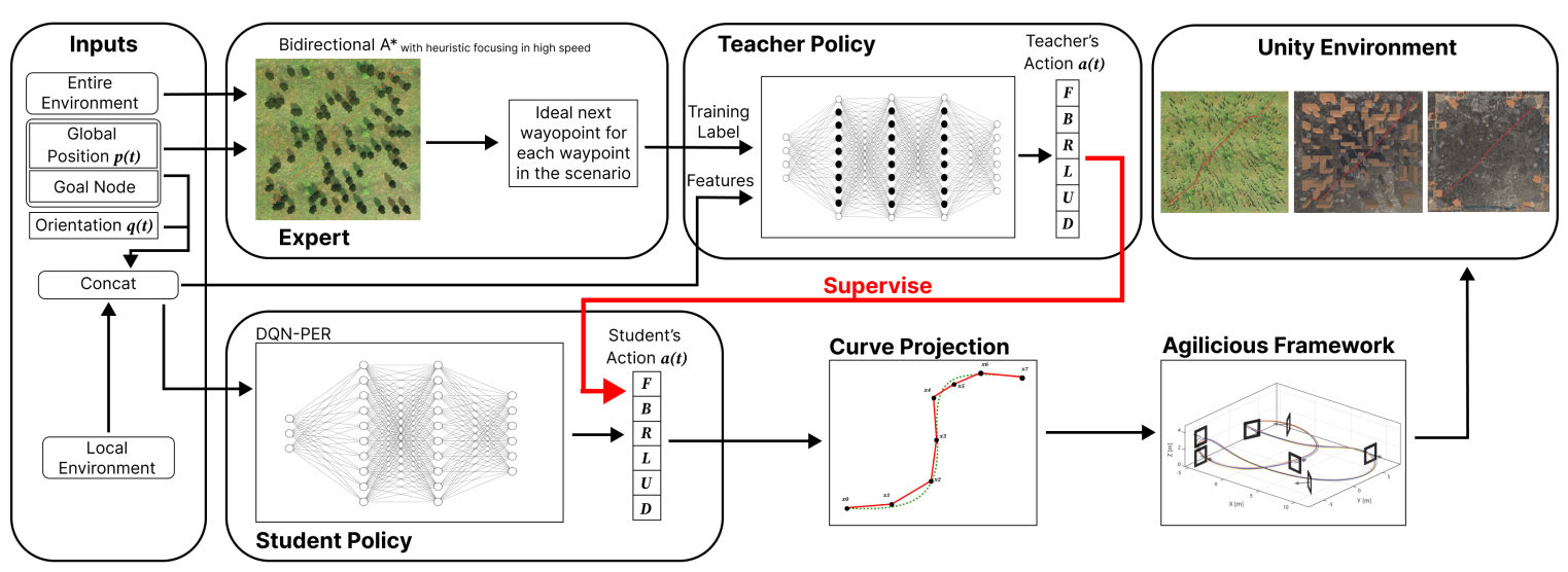
- The proposed method combines a supervised learning approach, as teacher policy, with deep reinforcement learning (DRL), as student policy.
- Train the teacher policy using a path planning algorithm that prioritizes safety while minimizing jerk and flight time.
- Use this policy to guide the learning of the student policy in various unknown environments.
- The proposed method combines a supervised learning approach, as teacher policy, with deep reinforcement learning (DRL), as student policy.

Introduction
- Previous works’ limitation
- Require
- Known environments.
- Extensive information for reliable outcomes, which is seldom the case in real-world missions.
- Require
- Proposed Method
- A trajectory planning method for generating agile flight trajectories in unknown environments solely based on data from onboard sensors.
- The framework integrates two neural networks:
- The teacher policy
- Supervised learning.
- Incorporates a geometry-based trajectory planning strategy enriched with a heuristic to optimize flight time and enhance safety.
- The student policy
- DQN-PER.
- The teacher policy
Methodology
- The primary aim
- The primary aim of our proposed approach is to facilitate the safe and agile navigation of UAVs in unknown environments, leveraging 3D LiDAR for environmental perception.
- Our strategy involves establishing the UAV trajectory with a minimal flight time based on real-time sensory data while prioritizing safety.
- The proposed privileged reinforcement learning framework
- The teacher policy
- Deep Feedforward Neural Network (DFNN).
- Trains using an expert algorithm proficient.
- Provides optimal action insights across diverse environments.
- Evaluates the student policy (DRL reward).
- The student policy
- DQN-PER
- Operates based on data identifiable by the UAV’s 3D Lidar around its current pose.
- Both networks output the new ideal waypoints to be followed (\(F\), \(B\), \(R\), \(L\), \(U\), \(D\)).
- The distilled knowledge from the teacher policy is integrated into the student policy, functioning without privileged information.
- The teacher policy

Problem Definition
- Our focus is on formulating a practical and reliable trajectory planning strategy, aiming to optimize three key objectives:
- Minimizing jerk.
- Reducing flight time.
- Enhancing safety by maximizing the distance to the obstacles in the environment.
- The goal is to minimize equations (1), (2), and (3) while maximizing (4) to enhance safety and ensure collision free trajectories for high-speed flights.
- Goal Distance: \(D_{\text{goal}} = \sum_{i=0}^n \sqrt{(\mathbf{p}_{\text{goal}} - \mathbf{p}_i)^2}\)
- Next Step Distance: \(D_{\text{next}} = \sum_{i=0}^{n-1} \sqrt{(\mathbf{p}_{i+1} - \mathbf{p}_i)^2}\)
- Jerk Cost: \(D_{\text{jerk}} = \int \left( \frac{d^3 \mathbf{p}}{dt^3} \right)^2 dt\)
- Obstacle Distance: \(D_{\text{obs}} = \max \sum_{j=0}^k \sqrt{(\mathbf{p}_i - \mathbf{O}_j)^2}\)
Expert
- Bidirectional A* algorithm
- We integrate objective equations as heuristics for trajectory generation: \(f(i) = (D_{\text{goal}} + D_{\text{obs}} + D_{\text{next}}) \times D_{\text{jerk}}\)
- Input:
- Entire environment.
- Global position.
- Goal Node.
- Output:
- The ideal next waypoint for each waypoint.
Teacher Policy
- The policy is trained across multiple randomly generated scenarios.
- Rainforests.
- Mazes.
- Disaster Areas.
- To ensure precision, a distinct model is learned for each scenario, resulting in 30 models trained across different scenarios, with 10 models for each environment.
- Input:
- Goal node.
- Global position.
- Orientation.
- The environment around within a 5 × 5 × 2 meter radius range.
- Output:
- (\(F\), \(B\), \(R\), \(L\), \(U\), \(D\)).
- The subsequent ideal action determined by our expert.
Student Policy
- The student policy efficiently produces real-time, collision-free trajectories for agile flights, relying solely on onboard sensor measurements.
- Input:
- obstacle positions within a 5 × 5 × 2 meter radius obtained from the 3D Lidar.
- UAV position
- Orientation.
- Goal node.
- Ouput:
- (\(F\), \(B\), \(R\), \(L\), \(U\), \(D\)).
- During flight, the UAV records obstacle positions, triggering policy execution upon identifying new obstacles.
- The policy generates a new trajectory using obstacle positions providing a single waypoint per iteration.
- Multiple policy runs are conducted to create the final trajectory.
- Upon generating a trajectory, it utilizes Bézier curves to transform the anticipated trajectory into a comprehensive state representation.

Results
- The proposed method is evaluated based on:
- Flight time (seconds)
- Processing time (seconds)
- Representing the time the UAV is at least at 80% of the maximum speed
- RMSE from the guidance trajectory (meters)
- Success rate (%)
- Baseline:
- the standard bidirectional A* in an unknown environment
- our expert operating in an unknown environment
- The original DQN-PER
- Our teacher policy
- Testing in simulation demonstrates noteworthy advancements, including an 80% reduction in tracking error, a 31% decrease in flight time, a 19% increase in high-speed duration, and a success rate improvement from 50% to 100%, as compared to baseline methods.

Enjoy Reading This Article?
Here are some more articles you might like to read next: